 |
| January 10, 2012 | Volume 08 Issue 01 |
Software News & Products
Designfax weekly eMagazine

Archives
Partners
Manufacturing Center
Product Spotlight
Modern Applications News
Metalworking Ideas For
Today's Job Shops
Tooling and Production
Strategies for large
metalworking plants
hyperMILL 2024 CAD/CAM software suite
 OPEN MIND Technologies has introduced its latest hyperMILL 2024 CAD/CAM software suite, which includes a range of powerful enhancements to its core toolpath capabilities, as well as new functionality for increased NC programming efficiency in applications ranging from 2.5D machining to 5-axis milling. New and enhanced capabilities include: Optimized Deep Hole Drilling, a new algorithm for 3- and 5-axis Rest Machining, an enhanced path layout for the 3D Plane Machining cycle, better error detection, and much more.
Learn more.
Find test data issues faster: AI Anomaly Detector
 It can take months of manual engineering time to detect test data abnormalities. Now the task can be performed in a flash. Artificial intelligence software provider Monolith has developed the industry's first AI-powered Anomaly Detector software that can discover a broad range of issues in test data fast -- measurement or sensor errors, user errors, system malfunctions, or incorrect usage of the system during testing. It does this by automating the process of raw test data inspection to look for potential errors or abnormalities across hundreds of test channels.
Learn more.
Loss-free conversion of 3D/CAD data
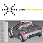 CT CoreTech-nologie has further developed its state-of-the-art CAD converter 3D_Evolution and is now introducing native interfaces for reading Solidedge and writing Nx and Solidworks files. It supports a wide range of formats such as Catia, Nx, Creo, Solidworks, Solidedge, Inventor, Step, and Jt, facilitating smooth interoperability between different systems and collaboration for engineers and designers in development environments with different CAD systems.
Learn more.
Top 5 reasons for solder joint failure
 Solder joint reliability is often a pain point in the design of an electronic system. According to Tyler Ferris at ANSYS, a wide variety of factors affect joint reliability, and any one of them can drastically reduce joint lifetime. Properly identifying and mitigating potential causes during the design and manufacturing process can prevent costly and difficult-to-solve problems later in a product lifecycle.
Read this informative ANSYS blog.
How a BattleBot was built using Onshape
 Learn how RoboGym Robotics, a veteran BattleBots team, said goodbye to Solidworks and took their design game to the next level using Onshape, the cloud-native, all-in-one CAD and PDM solution. RoboGym was able to analyze key components of their Roundhouse BattleBot like its armor and weapon bar, run simulations, collaborate, iterate, and optimize their design to its fullest.
Read this informative Onshape blog.
Trick to measuring angles in SOLIDWORKS
 Learn from the pros at TriMech how to take angle measurements easily in SOLID-WORKS. TriMech has an entire YouTube channel dedicated to SOLIDWORKS tips, and the company is excellent at training too.
View the video.
COMSOL Multiphysics Version 6.2 is here
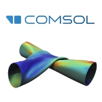 COMSOL Multiphysics Version 6.2 introduces faster solvers for turbulent fluid flow, electric motors, and room acoustics. It also brings data-driven surrogate model functionality for creating multiphysics-based digital twins and building fast and accurate standalone simulation apps. Get the full details of what's new in the latest version.
Learn more.
17 ways SOLIDWORKS 2024 helps you work faster
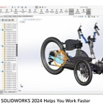 SOLIDWORKS 2024 helps designers and engineers work faster than ever. Learn all about improvements to core 3D CAD modeling features, new 3D modeling techniques, and graphical and software performance boosts that will help you get your parts made and your products developed in record time.
View the video.
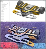
6 tips to streamline workflow in Mastercam 2024
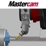 Mastercam 2024 CAD/CAM software has been intentionally upgraded to make programming fast and easy. It prioritizes streamlining workflow so that the entire machining process -- from design to QC -- is as efficient as possible. Learn how to maximize the benefits of Mastercam 2024, including special toolpaths, easier hole-making operations, wireframe shortcuts, and more.
Read this informative Mastercam blog.
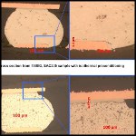
How CT data analysis is helping TE Connectivity reach their goal of end-to-end quality inspection
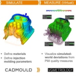 In a bid to cut their mold and part development process to 25% of the time it took in the past, TE Connectivity has taken ambitious steps to interconnect design and simulation with quality measurement. Learn how the company, in collaboration with PTC (Creo) and Volume Graphics, has worked to ensure as-designed parts match as-manufactured parts as early in the process as possible. An in-depth and illuminating read.
Read the full article.
State-of-the-art mesh morphing technology for super optimization: Ansys and RBF Morph join forces
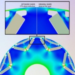 After a long and successful OEM partnership with Ansys, mesh morphing pioneer RBF Morph has two proprietary products featured among the world simulation leader's offerings: Ansys RBF Morph Fluids and Ansys RBF Morph Structures. Thanks to mesh morphing, companies can substantially reduce computational time while performing highly automated design optimization analysis, increasing products' reliability and performance while cutting costs, delivery time, and environmental impact.
Read the full article.
Top Tech Tip: Creating drafts with the rib feature in Onshape
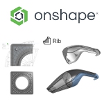 Ribs are used to add stiffness and strength to parts without adding excessive weight or increasing wall thickness -- most commonly in molded parts that require a draft angle so the part can release from the mold. See the basics of how this is done in Onshape, which features the power of cloud computing, real-time collaboration tools, and a built-in PDM system -- all for the same price as CAD.
Learn more.
How to design a spoon with subdivision modeling: SOLIDWORKS xShape
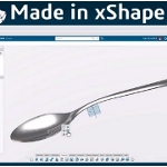 Learn how to design a spoon with SOLIDWORKS xShape, which is found in 3D Sculptor on the 3DEXPERI-ENCE platform. xShape is a next-gen subdivision modeling tool that runs entirely in your browser and takes a freeform approach to creating complex shapes and surfaces. You can design 100% in the cloud or seamlessly integrate your xShape models with your SOLIDWORKS designs. Follow along with this 7-minute tutorial to see what it's all about.
View the video.
What's new in Onshape?
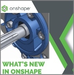 Check out the latest updates to Onshape, the cloud-native product development platform that delivers professional-grade CAD capabilities with next-gen product data management. New features include customizable keyboard shortcuts, better BOM navigation, improved drawing tools, and new Learning Center content. With Onshape, users can innovate quickly while simultaneously or asynchronously collaborating with other stakeholders on any web-connected device.
View the video.
Open-access learning center for multiphysics modeling
 COMSOL, the developer of the COMSOL Multiphysics simulation software, has introduced a new online resource that provides no-cost, open access to modeling and simulation learning material across all areas of physics. Designed with the user in mind, the Learning Center offers a single entry point for users of all skill levels, where courses, articles, and videos present a clear path for learning how to use COMSOL Multiphysics for modeling and simulation.
Check out the COMSOL Learning Center.
Software improves 3D GPS accuracy to centimeters; altitude measuring gets huge boost
By Jessica Orwig, Ohio State University
Researchers who are working to fix global positioning system (GPS) errors have devised software to take a more accurate measurement of altitude particularly in mountainous areas.
The software is still under development, but in initial tests it enabled centimeter-scale GPS positioning including altitude as often as 97% of the time.
Researchers hope the software will help to improve the vertical accuracy of measurements in potentially hazardous regions at high altitudes, such as areas of soft, loose land that may be prone to landslides. They also claim that their software could be used to measure how quickly glaciers at high altitudes are melting.
The GPS is most commonly known for its ability to provide on-the-spot locations for drivers, but this application is just one of many possible uses, explained Dorota Grejner-Brzezinska, professor of civil and environmental engineering and geodetic science at Ohio State University. As the level of GPS precision increases, so do potential applications for scientific research.
While drivers are generally concerned with tracking their own location in two dimensions on the Earth's surface, the third dimension of altitude has always been available through GPS just with lower accuracy than that of the horizontal coordinates.
Recently, Grejner-Brzezinska and her colleagues from the University of Warmia and Mazury in Poland have developed software that will allow GPS to relay locations to within a few centimeters' accuracy, including altitude. While this high level of precision is not necessary for driving directions, it is necessary for recognizing small shifts in topsoil that may lead to dangerously destructive landslides.
She explained that a lot is going on behind the scenes during a typical use of GPS.
GPS satellites transmit information in the form of radio waves to the GPS receiver held by the user. At the same time, the signals must also travel to at least one other ground-based receiver to obtain a location reference, which allows the user's receiver in turn to accurately calculate its own position in 3D. Before the satellite signals reach the receivers, they must travel through Earth's atmosphere, which results in time delays that affect accuracy.
When the user's receiver and the reference receiver reside at drastically different altitudes, however, each location experiences different amounts of time delay, which complicates matters even further. So, in mountainous regions where height differences can vary greatly over a short distance, acquiring the altitude of locations to within a few centimeters is difficult.
"Time is the heart that drives GPS, so it is important that we have a proficient method that accounts for delays from Earth's atmospheric layers," said Grejner-Brzezinska. "It would be ideal for all GPS signals to travel in a straight line directly to their destination, but due to electron interaction and refraction in the lower atmosphere, the signal's path is far from straight," she continued.
Electron interaction and tropospheric refraction effectively re-route the GPS signal, which means that the signal travels an extra distance and requires extra time, said Grejner-Brzezinska.
She and her colleagues looked specifically at troposphere delays those caused by the lowest level of the atmosphere. Their study can be found in a recent issue of the journal Measurement Science and Technology.
In the past, scientists have tried to account for troposphere delays by using basic models of Earth's atmosphere, said Grejner-Brzezinska. But these models may not fully account for changes in the weather or temperature, which can have a significant effect on the amount of interference the GPS signals experience on their way down to earth.
Not only weather and temperature, but also the height difference between two stations can greatly affect the accuracy of a GPS-based height determination.
Using ground station receivers located in the Carpathian Mountains in Poland a region known for its steep slopes the researchers collected GPS information over a 13-hour period.
They looked at two pairs of receivers with different height changes. The first pair was located 72 km apart and had a height difference of 32 m. The second pair was 66 km apart with a total height difference of 380 m.
"We figured that the easiest scenario would be provided by the receivers with 32-meter height difference, and the most challenging one with a height difference of 380 meters," said Grejner-Brzezinska.
Using processing software developed originally in Grejner-Brzezinska's lab at Ohio State, and further expanded by her research collaborators at the University of Warmia and Mazury in Poland, the researchers applied three different methods to measure GPS accuracy for the receivers.
The results showed that, out of the three methods of handling tropospheric delay in GPS measurements that were tested, there was one that provided an accurate location, including the height of the receivers, 97% of the time.
"Of the three methods we tested, the third and most accurate was also the most complicated," said Grejner-Brzezinska. "This method was developed by our team, and required knowledge of three or four reference stations in order to perform the calculations properly."
The other two methods did not require the use of multiple reference points just a single one but their levels of accuracy did not match the third method's positioning capabilities.
Further testing will follow. But this early study shows that GPS accuracy for altitude estimation can be improved, and may lead to the precision estimates that researchers need to analyze, for example, the stability of mountaintops and glaciers with 10-min temporal resolution.
This research was funded by the European Space Agency Plan for European Cooperating States project and a grant from the Polish Ministry of Science and Higher Education.
Grejner-Brzezinska's collaborators at the University of Warmia and Mazury include Pawel Wielgosz, Slawomir Cellmer, and Zofia Rzepecka.
Published August 2011
Rate this article
View our terms of use and privacy policy